Featured Map
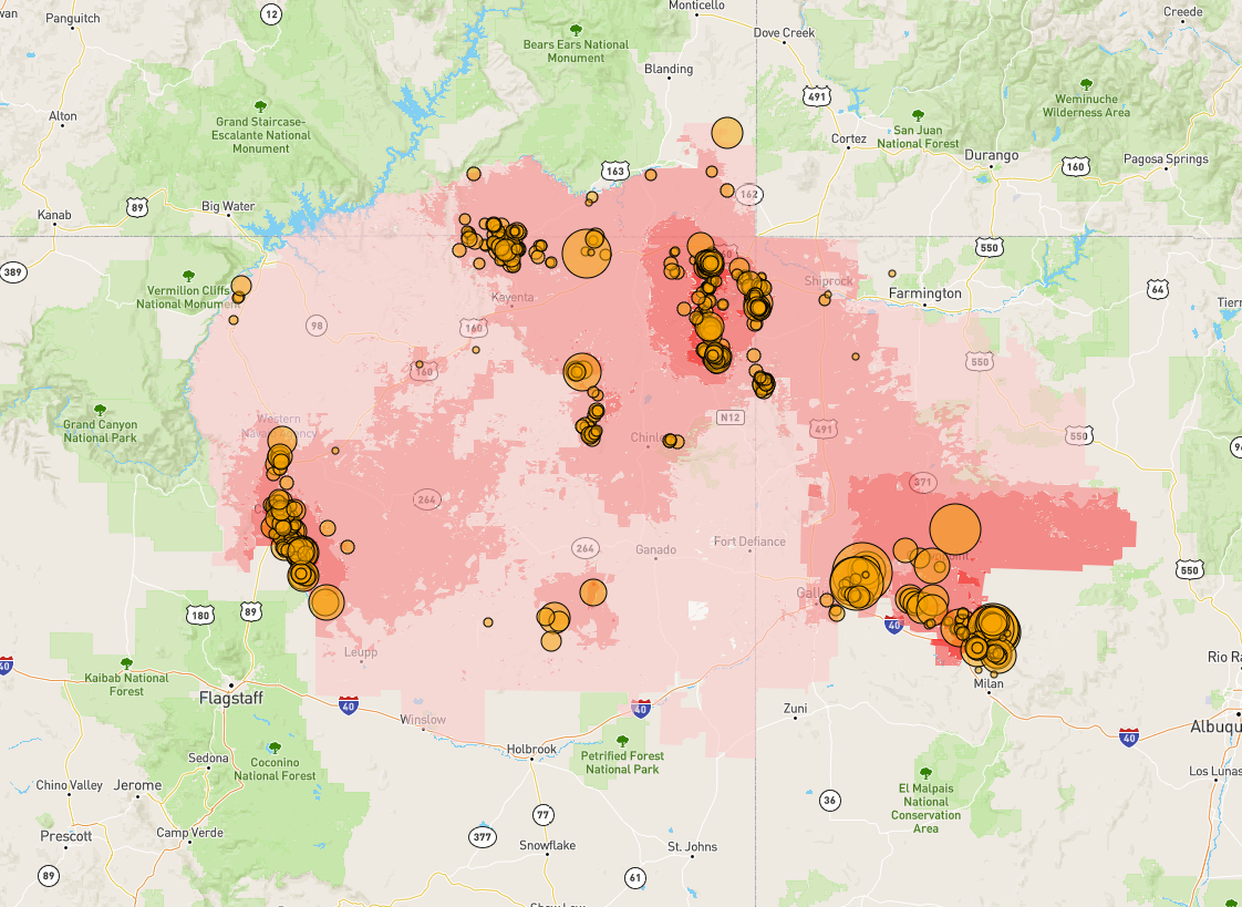
The Navajo Nation, an Indigenous Tribal nation in the intermountain west, continues to contend with the environmental and health impacts of uranium mining. Hundreds of these mines are left abandoned with little remediation, leading to the contamination of water, air, and soil. The long-term exposure to uranium can cause a multitude of adverse human health effects.
To model the potential for exposure to abandoned uranium mines (AUMs) in the Navajo Nation from a geospatial perspective, Lin et al. (2020) applied a GIS-based multi-criteria decision analysis (GIS-MCDA). Their model outputs a 30x30m grid, with each cell value representing the potential exposure to AUMs as a fuzzy-logic standardized index based on the input of several environmental criteria. Environmental criteria include the proximity to abandoned uranium mines, proximity to roads, and several hydro-geotechnical, meteorological, and biological factors.
The displayed web map was developed by graduate students Theodros Woldeyohannes, Eric Brannen, Maggie Ramirez, and Dr. Liping Yang in her Internet Web Mapping class (GEOG 485L/585L). The web map takes the output of Lin et al.’s MCDA model and makes it interactive, allowing for users to pan and zoom in on specific locations, and see the predicted potential exposure distribution in detail for a specific area of interest. Additionally, the locations of AUMs are mapped as interactive objects the user can click-on to view mine information. The user can also choose to filter displayed mines by size-ranges.
The web map was initially inspired by the UNM College of Pharmacy Navajo Water GIS map, developed by Daniel Beene and Manideep Potluru. Theodros Woldeyohannes and Eric Brannen are both PhD students in geography and advisees of Dr. Yan Lin, conducting GIS based research into public health issues at the Health and Environmental Research GIS Lab. Eric Brannen conducts research on access to treatment and health outcomes for breast cancer patients in New Mexico. Theodros Woldeyohannes conducts community-engaged environmental health research with multiple Native American communities throughout the Intermountain West. Maggie Ramirez is an MS student in urban planning and conducts research on community development.
Web map: https://theodros-woldeyohannes.github.io/MyWebApp
